| |
| Highlights: |
 Loughaveema is known as a vanishing lake and most of
the arguments surrounding its origin centre on the solid geology
especially the ability of chalk to gradually drain the lake. The area
surrounding the lake is extremely aesthetic and this is directly due to
topographic diversity provided by the juxtaposition of the post-glacial
peat drape on a craggy glaciated landscape furrowed by steep sided,
glacial meltwater channels. Loughaveema is known as a vanishing lake and most of
the arguments surrounding its origin centre on the solid geology
especially the ability of chalk to gradually drain the lake. The area
surrounding the lake is extremely aesthetic and this is directly due to
topographic diversity provided by the juxtaposition of the post-glacial
peat drape on a craggy glaciated landscape furrowed by steep sided,
glacial meltwater channels.
|
| Introduction: |
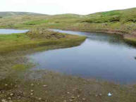
The small lake of Loughaveema provides an interesting
example of fluctuating lake levels which are controlled largely by
ground water drainage along the axis of a glacial meltwater system. At
times of excessive rainfall water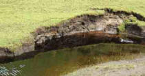 levels rise to a maximum and are
controlled by an outlet to the north. During the summer months lake
levels progressively fall due to depletion by ground water seepage and a
series of temporary shorelines or washing limits are exposed. The latter
reflect successive lake levels as small sandy or gravelly erosional and
winnowed shoreline traces. When summer rainfall totals are low the basin
will drain completely. levels rise to a maximum and are
controlled by an outlet to the north. During the summer months lake
levels progressively fall due to depletion by ground water seepage and a
series of temporary shorelines or washing limits are exposed. The latter
reflect successive lake levels as small sandy or gravelly erosional and
winnowed shoreline traces. When summer rainfall totals are low the basin
will drain completely.
|
| Description: |
| The small lake occurs towards the centre of a broad
depression (2km / to 3km / ) which is developed mainly in Dalradian
rocks. The depression is bounded by the watershed running from
Carnanmore south to the Cushleake Mountain/Crockaneel and south again to
Carneighaneigh Mountain.
The lake is sited along a major glacial meltwater channel system
where several smaller channels join the main channel. The main channel
is cut in rock, is generally 80m to 90m in width and bounded by steep
rock slopes which are either composed of rocky crags or draped with
peat. The meltwater channel begins with an 'open intake' (250m O.D.) 1km
south of Loughaveema and continues north-northwestwards as a prominent
meltwater channel into the Carey Valley. The system increases greatly in
size northwards.
The specific site of the lake occurs at a bend in the glacial
meltwater channel where its orientation changes from north- northwest to
northwest. In addition three small meltwater channels cut in rock and up
to 10m to 15m in depth occur on the eastern side of the lake on the
rising slopes of Cushleake Mountain. They are currently occupied by
small streams. The erosional form of these channels have locally
sculpted the eastern margins of the lake basin into a series of rocky
crags separating the channels whereas the western margin of the feature
is bounded by the continuous, steep margin of the main meltwater gash.
As a result, the shape of the lake is elongated along the main channel
but minor irregularities in outline and small bays are related to the
position of minor channels. At the northern lake margin recent changes
in the lake margin are currently being changed by peat cutting and mass
movement of peat and other detritus. On the western site of the lake
coarse-grained, poorly- sorted diamict and gravelly detritus of glacial
origin rests on and drapes the bedrock margin along the roadside near
the stream draining the lake. The detritus is composed mainly (90%) of
Dalradian clasts with occasional red granite erratics.
At a maximum the water surface measures about 150m across (W-E) and
300m from north to south. Maximum water levels rise to about 217-218m
O.D. and are controlled by the small stream draining to the north. This
has recently been deepened and cleaned. It is lined by soliflucted
glacial detritus which is not in situ.
|
| Importance: |
| The geomorphic phenomena of a vanishing lake and the
glacigenic landforms around Loughaveema are probably only scientifically
important at a local level. However the unique combination of geomorphic
elements provide a landscape characterised by high aesthetic qualities
and the feeling of remoteness. The glaciological inferences at the site
indicate the local ice flow, meltwater directed drainage and various ice
marginal halts.
|
| Interpretation: |
| Traditionally the fluctuating lake levels of the
lough were explained with reference to gradual drainage of lake waters
through either an underlying or adjacent stratum of Cretaceous chalk.
Geological maps (eg. GSNI Sheet 2; Charlesworth, 1963, Figure 73) show a
unit of chalk along the northern margin of the lake. However, the
current state of the outcrops suggest that the main lake basin is sited
within the Dalradian which has a low transmissibility. There is also
some doubt regarding the ability of the hard chalk to transmit lake
waters unless it is fractured or able to support physically a network of
solutional pipes. Therefore the field evidence though attractive and
simple does not fully explain the observed fluctuations in lake levels.
There are two fundamental problems concerning the origin of the lake
basin. First the topographic location of the lake basin could be
adequately explained with reference to its location within the meltwater
channel. The open intake morphology of the channel, its pattern of
tributary junction angles and gradients, together with its relationship
to cross-valley moraines farther north indicates it is subglacial in
origin. Extensive deltas of sand and gravel within the Carey Valley
farther north indicate it transported vast quantities of sediment into
ponded water related to high relative sea level (McCabe and Eyles,
1988). Channel gradient also indicates ice directed drainage while thick
ice covered the Loughaveema Basin. The gradient of the ice lobe was
therefore from south to north in the basin. Cross-valley moraines point
to a southerly ice recession during which the valley fill was trenched.
It is therefore argued that the erosion of the actual lake basin is a
result of intense fluvioglacial activity as subglacial meltwater was
directed northwards. The position of the overdeepened and enlarged basin
with its irregular eastern margin is simply a function of an increased
and abrupt input of glacial meltwater into the channel system at this
site. This is supported by the three subglacial channels joining the
system from the east. However these are relatively small and it is
suggested that an englacial conduit draining the ice lobe concentrated
high energy meltwaters to form a subglacial plunge pool. The present
form of the depression and local increase in erosion of the subglacial
system at this point both point to this hypothesis.
Second, the phenomena of fluctuating lake levels cannot be fully
explained by the structural geology of the immediate area. As the lake
lies astride a meltwater channel, floored by irregular patches of
pervious, coarse-grained gravelly diamict, it is suggested that effluent
seepage below the channel floor is the main process responsible for lake
drainage and control of lake levels. Groundwater seepage of this type
along partially buried portions of meltwater channels may be more
important that hitherto realised in the control of water levels within
glaciated terrain. This inference has important implications on the
dispersion of environmental pollutants and water quality within larger
systems (buried) in the lowlands.
|
| Conclusions: |
| Loughaveema is sited at a junction of several
channels along a subglacial channel system which conducted meltwater
northwards during the last deglaciation. It occurs at a point where
meltwater from subglacial and englacial sources were focussed in a
plunge pool. Fluctuating lake levels are a function of run off intensity
and duration combined with seepage to groundwater and streams probably
through a permeable fill northwards along the base of the meltwater
channel. The lake acts as a sort of reservoir which sustains some water
flow into the Carey Valley. |
| Notes: |
The surrounding slopes are draped by peat.
However, recent and current peat cuttings are rapidly degrading the
visual attraction of the site in two main ways. Firstly, on the northern
margins of the lake, cuttings close to lake level, are extending the
lake margin into the new cuttings at times of high lake level. A muddy
morass along this sector of the lake margin will result. Secondly,
shallower peat extractions on the slopes above the eastern lake margin
are focussing drainage leading to mass flow of peat, and incipient signs
are present which indicate that slope movement will soon occur. There
are also patterns of wheeled vehicles across some areas of peat which
will not help the situation. |


